Geology
print

Links and Functions
Language Selection

Breadcrumb Navigation


Content

Active Tectonics, Tectonic Geomorphology, and Earthquake Studies

ChiChi_eq_racetrack

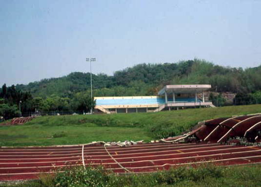
Surface rupture of the 1999 Mw 7.7 ChiChi, Taiwan, earthquake cutting across the stadium of Kuangfu Junior High School at Wufeng. It is a textbook example of fault scarps of thrust earthquakes. An earthquake museum with a roof over this part of the racetrack was later built, to preserve the scarp and educate people about earthquakes. (Photo © S. Carena, March 2000) 

People

Anke FriedrichSara CarenaSimon KüblerStefanie Rieger, Mjahid Zebari, Beth Shaw-Kahle

3-D structural and tectonic modeling

Ridgecrest_3DWe apply 3-D structural modeling to a variety of problems (from 3D fault modeling of individual faults to the behavior of complex fault networks and of accretionary wedges). Courses and workshops in modeling are offered, depending on demand from students.

Tools: we currently have licenses for SKUA-GocadTM and use various state-of-the-art free and shareware software specifically designed for mapping and structural analysis (GMDE, Stereonet 11, FaultFold, Trishear3D).


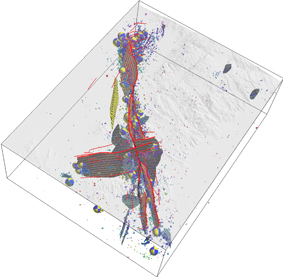
Fault network of the 2019 Ridgecrest earthquakes.

Recently closed project: DFG Project no. 408273939 (S. Carena), 2018 - 2022: 3D Geometry and Kinematics of the Taiwan Arc-Continent Collision from 3D Mapping.


Detection of active vertical deformation using Radar Interferometry

Crete_3D_PSI_Faults


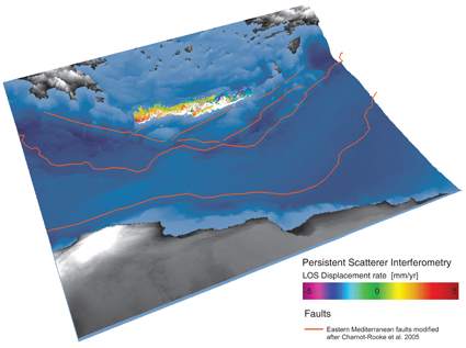
The detection of the vertical deformation patterns of the Earth's surface allows us to identify active tectonic processes.

We use Persistent Scatterer Interferometry on a regional scale to better understand active tectonics and earthquake geology on the island of Crete. 


Aspentech_logo    logo_ring_blanc


We study how the earth’s surface responds under climatic, tectonic and human influences and how dynamic landscapes evolve over timescales from thousands to millions of years. To do this, we combine field mapping approaches with remote sensing and geospatial analysis, as well as numerical and agent-based computer modeling approaches.
People

Simon Kübler, Mjahid Zebari

Landscape evolution in tectonically and climatically dynamic regions

Landscape evolution model of an exposed anticline (Zebari et al., 2019). In the model, the topography of a less mature anticline serves as input to estimate the time that takes its landscape to reach the maturity level of more mature anticline. This time can be considered as the relative time difference between the exposure of more mature and less mature anticlines. The model uses components of the Python-based open-source Landlab toolkit (Hobley et al., 2017; Barnhart et al., 2020; http://landlab.github.io).

Surface roughness, paleolake levels and Paleoindian sites of Late Pleistocene Chewaucan lake, southern Oregon (Kübler et al., 2019). Pleisto-Holocene lake level fluctuations in combination with tectonic and volcanic activity caused drastic landscape changes caused by isostatic surface motion of the basin floor and landslide activity. Paleotopography created with lakeflexer component of the Landlab toolkit, map created with Global Mapper v. 20.

Rock-soil interactions in tectonic landscapes

Interview with BBC Earth on "The volcano that drives the Great Wildebeest Migration"

Soil variability in geologically and topographically complex regions (Kübler et al., 2021). (a) Variations of soil organic carbon in the southern Kenya Rift, East Africa (b) correlation between soil organic carbon and evergreen vegetation.

Sampling trona deposits at the shorelines of Lake Magadi, southern Kenya Rift. High Na and Ca levels in the evaporites strongly affect soil properties in the wider vicinity e.g. through eolian transport (Kübler et al., 2015, 2021), and determine seasonal migrations of grazing animals (Kübler et al., 2015, 2016).

Extensive sheet erosion resulting from overgrazing and savannah wildfires in Serengeti National Park, Tanzania. Erosion leads to widespread soil degradation through partial removal of the thin topsoil layer above bedrock (Kornei 2020).

Publications

Kornei, K., 2020, Geology and Chemistry Drive Animal Migration in the Serengeti. EOS,101, https://doi.org/10.1029/2020EO144423

Kübler, S. Rucina, S., Aßbichler, D., Eckmeier, E., and King, G.C.P., 2021, Lithological and topographic impact on soil nutrient distributions in tectonic landscapes: implications for Pleistocene human-landscape interactions in the southern Kenya Rift, Frontiers in Earth Science, v. 9 (103).

Kübler, S., Bailey, G., Rucina, S., Devés, M., and King, G.C.P., 2020, Rift Dynamics and Archaeological Sites: Acheulean Land Use in Geologically Unstable Settings. Archaeopress Archaeology, doi:10.2307/j.ctvx5w983.8

Kübler, S., King, G.C.P., Devés, M., Inglis, R., Bailey, G., 2019. Tectonic geomorphology and soil edaphics as controls on animal migrations and early human settlement and dispersal. In Rasul and Stewart (eds.) Geological Setting, Palaeoenvironment and Archaeology of the Red Sea. Springer International.

Kübler, S., Rucina, S, Reynolds, S, Owenga, P, Bailey, G and King, G.C.P., 2016. Edaphic and Topographic Constraints on Exploitation of the Central Kenya Rift by Large Mammals and Early Hominins. Open Quaternary, 2: 5, pp. 1–18.

Kübler, S., Owenga, P., Reynolds, S.R., Rucina, S., King, G.C.P., 2015. Animal movements in the Kenya Rift and evidence for the earliest ambush hunting by hominins. Scientific Reports 5, 14011 doi: 10.1038/srep14011

Zebari, M., Grützner, C., Navabpour, P., and Ustaszewski, K., 2019. Relative timing of uplift along the Zagros Mountain Front Flexure (Kurdistan Region of Iraq): Constrained by geomorphic indices and landscape evolution modeling. Solid Earth, 10, 663-682. https://doi.org/10.5194/se-10-663-2019
Active Projects

Since 2022: Bayerisches Förderprogramm zur Anbahnung internationaler Forschungskooperationen (BayIntAn_LMU_2022_32): “Die Auswirkungen des Klimawandels und anthropogener Einflüsse auf die ostafrikanischen Rift Seen“.

Since 2021: PaleoLesbos – Phase II: paleolandscape evolution and Midpleistocene hominin dispersal in the Aegean basin“ (Collaboration with Nena Galanidou, University of Crete; funded by Wenner-Gren Foundation and Costopulus Foundation).
Closed Projects

2018-2020 DFG postdoctoral fellowship (KU 3512/2-1): “Paleolandscape-reconstructions of tectonically active regions - a new tool to predict fossil site locations and discern patterns of hominin inhabitance”.

2019 Innovationsfond@GEO, Fakultät für Geowissenschaften, LMU München: “From Rocks to Soils to Gnus: Exploring geological and pedological factors as potential drivers of the Great Wildebeest Migration in the Serengeti ecosystem, N-Tanzania (East Africa)”.

2018 Bayerisches Förderprogramm zur Anbahnung internationaler Forschungskooperationen (BayIntAn_LMU_2018_89): “Bilateral Funding: Investigating the role of geological and pedological factors in the evolution and dispersal of early humans in tectonically active regions of western North America“.

2016 Bayerisches Förderprogramm zur Anbahnung internationaler Forschungskooperationen (BayIntAn_LMU_2016_102): "Antragsvorbereitung zu geologisch-archäologischer Feldforschung im Kenia Rift".


Last updated: 13.07.2025