

Geological Earth Surface Processes
We study how the earth’s surface responds under climatic, tectonic and human influences and how dynamic landscapes evolve over timescales from thousands to millions of years. To do this, we combine field mapping approaches with remote sensing and geospatial analysis, as well as numerical and agent-based computer modeling approaches.
People
Landscape evolution in tectonically and climatically dynamic regions
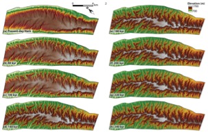 Landscape evolution model of an exposed anticline (Zebari et al., 2019). In the model, the topography of a less mature anticline serves as input to estimate the time that takes its landscape to reach the maturity level of more mature anticline. This time can be considered as the relative time difference between the exposure of more mature and less mature anticlines. The model uses components of the Python-based open-source Landlab toolkit (Hobley et al., 2017; Barnhart et al., 2020; http://landlab.github.io).
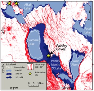 Surface roughness, paleolake levels and Paleoindian sites of Late Pleistocene Chewaucan lake, southern Oregon (Kübler et al., 2019). Pleisto-Holocene lake level fluctuations in combination with tectonic and volcanic activity caused drastic landscape changes caused by isostatic surface motion of the basin floor and landslide activity. Paleotopography created with lakeflexer component of the Landlab toolkit, map created with Global Mapper v. 20.
Rock-soil interactions in tectonic landscapes
Interview with BBC Earth on "The volcano that drives the Great Wildebeest Migration"
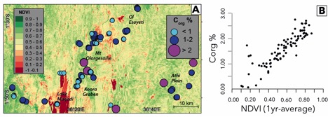
Soil variability in geologically and topographically complex regions (Kübler et al., 2021). (a) Variations of soil organic carbon in the southern Kenya Rift, East Africa (b) correlation between soil organic carbon and evergreen vegetation.
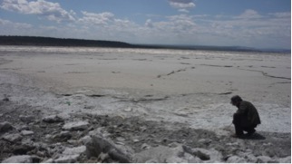 Sampling trona deposits at the shorelines of Lake Magadi, southern Kenya Rift. High Na and Ca levels in the evaporites strongly affect soil properties in the wider vicinity e.g. through eolian transport (Kübler et al., 2015, 2021), and determine seasonal migrations of grazing animals (Kübler et al., 2015, 2016).
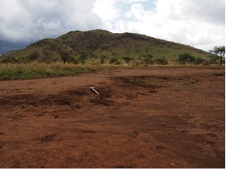 Extensive sheet erosion resulting from overgrazing and savannah wildfires in Serengeti National Park, Tanzania. Erosion leads to widespread soil degradation through partial removal of the thin topsoil layer above bedrock (Kornei 2020).
Publications
Kornei, K., 2020, Geology and Chemistry Drive Animal Migration in the Serengeti. EOS,101, https://doi.org/10.1029/2020EO144423
Kübler, S. Rucina, S., Aßbichler, D., Eckmeier, E., and King, G.C.P., 2021, Lithological and topographic impact on soil nutrient distributions in tectonic landscapes: implications for Pleistocene human-landscape interactions in the southern Kenya Rift, Frontiers in Earth Science, v. 9 (103).
Kübler, S., Bailey, G., Rucina, S., Devés, M., and King, G.C.P., 2020, Rift Dynamics and Archaeological Sites: Acheulean Land Use in Geologically Unstable Settings. Archaeopress Archaeology, doi:10.2307/j.ctvx5w983.8
Kübler, S., King, G.C.P., Devés, M., Inglis, R., Bailey, G., 2019. Tectonic geomorphology and soil edaphics as controls on animal migrations and early human settlement and dispersal. In Rasul and Stewart (eds.) Geological Setting, Palaeoenvironment and Archaeology of the Red Sea. Springer International.
Kübler, S., Rucina, S, Reynolds, S, Owenga, P, Bailey, G and King, G.C.P., 2016. Edaphic and Topographic Constraints on Exploitation of the Central Kenya Rift by Large Mammals and Early Hominins. Open Quaternary, 2: 5, pp. 1–18.
Kübler, S., Owenga, P., Reynolds, S.R., Rucina, S., King, G.C.P., 2015. Animal movements in the Kenya Rift and evidence for the earliest ambush hunting by hominins. Scientific Reports 5, 14011 doi: 10.1038/srep14011
Zebari, M., Grützner, C., Navabpour, P., and Ustaszewski, K., 2019. Relative timing of uplift along the Zagros Mountain Front Flexure (Kurdistan Region of Iraq): Constrained by geomorphic indices and landscape evolution modeling. Solid Earth, 10, 663-682. https://doi.org/10.5194/se-10-663-2019
Active Projects
Since 2022: Bayerisches Förderprogramm zur Anbahnung internationaler Forschungskooperationen (BayIntAn_LMU_2022_32): “Die Auswirkungen des Klimawandels und anthropogener Einflüsse auf die ostafrikanischen Rift Seen“.
Since 2021: PaleoLesbos – Phase II: paleolandscape evolution and Midpleistocene hominin dispersal in the Aegean basin“ (Collaboration with Nena Galanidou, University of Crete; funded by Wenner-Gren Foundation and Costopulus Foundation).
Closed Projects
2018-2020 DFG postdoctoral fellowship (KU 3512/2-1): “Paleolandscape-reconstructions of tectonically active regions - a new tool to predict fossil site locations and discern patterns of hominin inhabitance”.
2019 Innovationsfond@GEO, Fakultät für Geowissenschaften, LMU München: “From Rocks to Soils to Gnus: Exploring geological and pedological factors as potential drivers of the Great Wildebeest Migration in the Serengeti ecosystem, N-Tanzania (East Africa)”.
2018 Bayerisches Förderprogramm zur Anbahnung internationaler Forschungskooperationen (BayIntAn_LMU_2018_89): “Bilateral Funding: Investigating the role of geological and pedological factors in the evolution and dispersal of early humans in tectonically active regions of western North America“.
2016 Bayerisches Förderprogramm zur Anbahnung internationaler Forschungskooperationen (BayIntAn_LMU_2016_102): "Antragsvorbereitung zu geologisch-archäologischer Feldforschung im Kenia Rift".
Last updated: 18.02.2022